FINALLY, the day we’d been waiting for had arrived! It was time to leave the U.S., cross the Gulf Stream, and realize our dream of sailing to the Bahamas. We’d headed to bed early the night before, but had a VERY hard time sleeping, and the alarm going off at 3am was not pleasant. After getting some coffee and a few cookies in us to get us going, and one last check on the weather, we got busy.
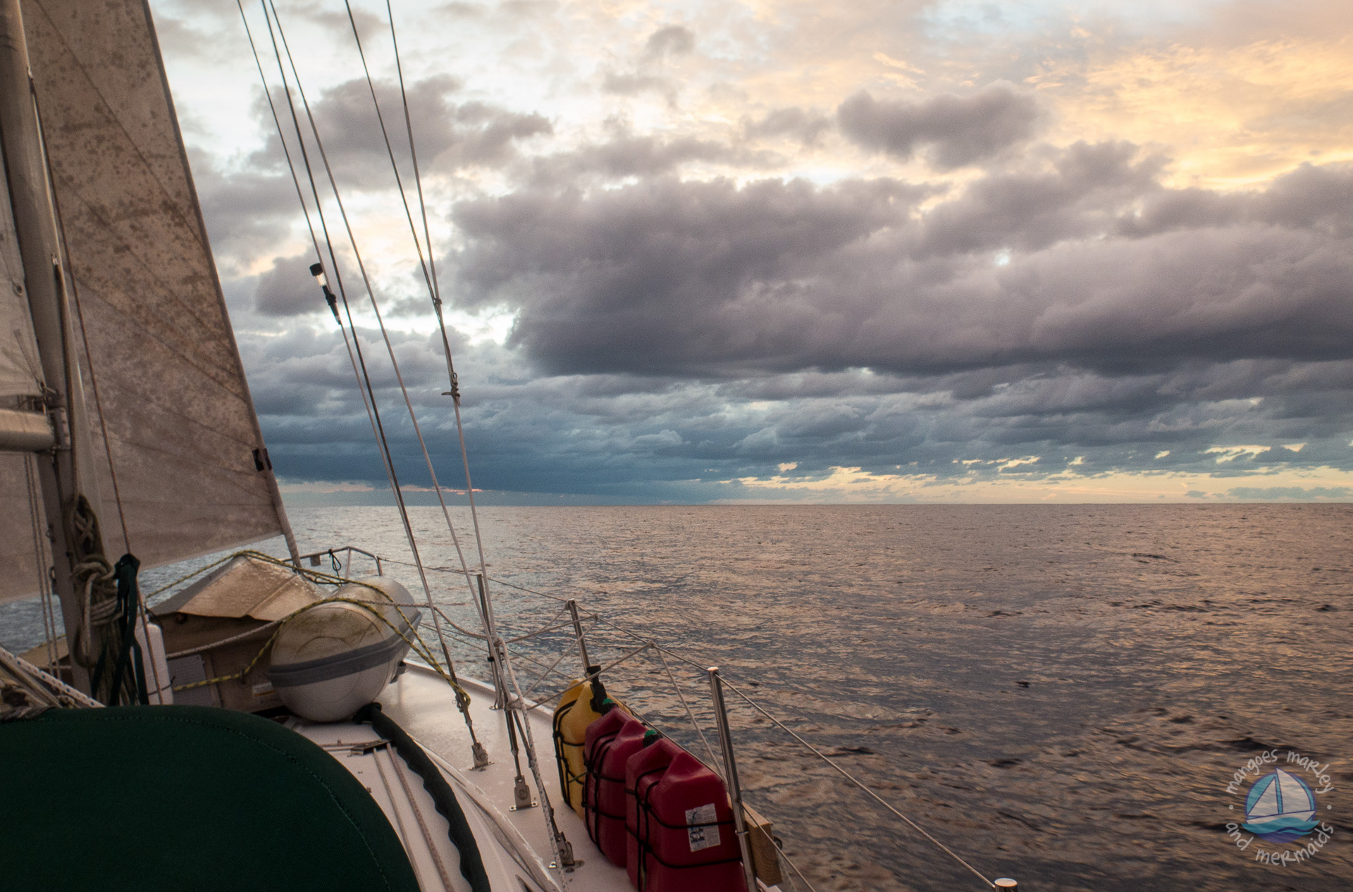
The night before we had raised the dinghy up out of the water (using our spinnaker halyard and a winch) and lashed it upside down on the foredeck so that we wouldn’t have to tow it. One less thing to worry about. Earlier in the day we had made sure that our diesel and water tanks were full, as well as all of our spare jerry cans. We carry 14 extra gallons of water, and 10 extra gallons each of diesel and gasoline (for the dinghy motor) on deck. We’d also stowed everything that we could down below as best as we could so nothing loose could go airborne and break or hurt one of us!
Anyhow, so now it was time to raise the anchor and get outta Dodge. We’d been in Lake Worth for so long and the anchor was dug in to the muddy bottom pretty well, so it took some extra muscle to lift it. Oh yeah, and remember the dinghy that’s now on the foredeck? Well, it’s sitting right where Jim needs to work making things a bit more complicated. We also don’t want all the mud that’s covering the chain and anchor in our boat, so we’ve got a washdown pump, which draws in sea water, installed near the front of the boat. I hose it all off while Jim pulls it up. Everything’s always about teamwork on the boat.
And then we were on our way! In the dark. In new surroundings. With little sleep. So, just to be sure I was going where I was supposed to be going, Jim stood on the bow and we had our headsets on so we could talk as needed while we motored down our last five-mile stretch of the ICW heading towards the Lake Worth inlet. Since there hadn’t been a weather window for crossing in quite some time, I totally expected to see another Bahamas bound boat or two also out and about, but we saw no one.
Soon after going through the inlet and out into the ocean (almost seems like it should be called an outlet if you’re heading out, dontcha think?!?) we felt the air temperature get warmer. Could we have already reached the Gulf Stream? I have to admit that before we decided to sail to the Bahamas, I never really knew what the Gulf Stream was. Now I do. Wow, do I ever! It’s basically a warm northeastern flowing ocean current. How wide, deep and strong the current is constantly changes, but it’s typically about 45 miles wide and flows at about 3-4 miles per hour and the water temperature is about 80 degrees.


We were only a couple of miles offshore when we felt the temperature change, so weren’t really sure if we were in the Gulf Stream already, but as soon as we realized that we were drifting north off our course we knew that we had definitely hit it! The water was pretty rough and we were moving very slowly, which was really causing us to get pushed north even more than we had expected. At one point we were steering to 115 degrees, but in reality were heading to about 70 degrees! The seas were much rougher than we were expecting and we were now being pushed way north of our intended route to Memory Rock, about 15 miles north of West End, Grand Bahama.
The forecast had been for a two foot swell…how nice that would have been. What we were seeing instead were four to six-foot steep waves (with occasional eight footers) right on the nose that were hitting about every 3.5 seconds. Not fun. At all. We were both feeling a bit queasy and hadn’t eaten anything since those cookies we’d had when we first woke up, so around noon I made a couple of PB&Js. I knew we really needed to eat something, and I was able to eat a whole one, but Jim only managed to down half of his.
This video was taken a bit later in the afternoon after it had started to calm down a bit. It never looks quite as daunting on video as it does in person…trust me!
We soon realized that there was no way we were going to make it to our intended waypoint just south of Memory Rock, so we gave in and headed instead for another common waypoint north of Memory Rock at White Sands, another 12.5 miles further north. The current was just so crazy…at one point we adjusted our course by 15 degrees to port (left) and caught a little bit of wind in our main sail (which up until then had been up mainly to give us some stability). This little boost from the wind helped our boat speed go from 3-3.5 kts up to 5-5.5 kts, and our course actually ended up staying about the same or maybe even changed by a few degrees to starboard (right)! Crazy, huh?
About 11 miles west of the Bahama Banks, we started noticing our course veering more to starboard, which meant that we were now seeing less influence from the current of the Gulf Stream, and were now were able to point further north and motor sail a little more comfortably towards our new waypoint.
About five miles before the Banks, the seas grew noticeably calmer, and as we got nearer, we could see the line of color change in the water where the water depth got shallow rapidly. We had been in waters 2,000 feet deep and within a matter of minutes were in 20 feet of water. This was our first glimpse of the beautiful turquoise water of the Bahamas!


Once in the protection of the Banks, things calmed way down and the water temperature started to drop. It had been around 76 degrees in the Gulf Stream and quickly dropped to 70 and got as low as 62 later in the evening. We were finally over the queasiness, so Jim grilled some hot dogs which we ate sitting in the cockpit as the sun was setting. We were now enjoying a smooth, comfortable motor, straight into the wind, and had taken down the main sail, when all of a sudden the engine RPMs dropped considerably and the engine started to run very rough. Sigh. Jim had JUST sent an email via ham radio to let our family know that all was well in our world. Had we just jinxed ourselves?
We slowed down to an idle and put the engine in neutral, where it idled normally. Jim spun the propshaft manually and said everything felt fine. He was worried then that maybe an injector had failed, so he took off the engine cover. All looked fine and there were no cold cylinders, so it appeared this was not the case. We were stumped, and getting a little worried. We put it back in gear and revved the engine. It seemed to work fine at slower speeds, but rough at higher RPMs. This is when we thought that maybe we had something wrapped around the prop. So, we put the engine in reverse, revved it and watched a bit of seaweed spit out from under the boat. We repeated this a few times, dislodging some more, so it appears that we must have simply run over a large clump of floating seaweed. It was just starting to get dark now, and Jim contemplated jumping in and checking the prop. However, the water temp had now dropped considerably, it was getting harder to see in the water, and there are known to be sharks in this area. It would’ve been a bit spooky and he ended up deciding against it…as would I have!


With the engine now running somewhat normal (but not as good as it could have been), we kept on our way and took turns on watch while the other tried to catch a little sleep. Oh yeah…and speaking of trying to catch things…we were so bummed at how rough it was in the Gulf Stream since we were really hoping to try our hand at catching a fish – preferably a Mahi or tuna! It was so rough though, that if we’d ended up catching something, it would have been next to impossible to reel it in, and no fun at all (and maybe even a bit dangerous?) trying to clean it in our bucking bronco of a boat. Oh well. Maybe next time.
In the wee hours of the morning we finally dropped anchor near about six other boats at Great Sale Cay. It had been very eerie traveling blindly along the banks totally trusting the accuracy of the chart and app we’d just decided on and bought the day before*, so it was definitely a relief to be safely anchored. We hit the sack about 3:30am with an alarm set for 6:30am, a mere three hours away. But this time, I’m pretty certain we both fell soundly asleep pretty darn quick!
By 7:30 the next morning we were on our way, once again motoring straight into the wind for the most part. We did get a nice rain shower to help wash off a lot of the salt we had no doubt collected as we pounded through the Gulf Stream, and compared to the day before, today was a piece of cake, topped off by the fact that I saw a couple of sea turtles and a few dolphins along the way!
At 5pm we dropped our anchor in front of Manjack Cay (pronounced Munjack Key) and raised our yellow Q, or quarantine flag to signify that we had not yet officially checked in to the country, made some dinner and were in bed by 9pm, which is highly unusual for us! We were exhausted, but we were in the Bahamas and could see our anchor (and a huge starfish!) on the bottom. We were content. Exhausted, but content.

*The new chart and app we had just purchased is Garmin Blue Chart Mobile which we are using on our iPad mini with the Bad Elf Pro Bluetooth GPS which we had just had delivered to the UPS store the day before we left. We needed the Bad Elf because our iPad does not have a GPS in it. We had been using SEAiq in the US, which we loved, but it doesn’t support the charts we needed for the Bahamas.
Debbie connolly
February 26, 2016 at 3:28 pmYou should be proud! We crossed in fact calm and that was an achievement! Enjoy Paradise!
Chris
February 26, 2016 at 4:52 pmHa ha! Thanks!
mary connaughton
February 26, 2016 at 3:36 pmGood job! We actually hung a right from Lake Worth and went south for 3 hours before heading across…enjoy!
Chris
February 26, 2016 at 4:56 pmThanks! We knew to head on a more southerly route, but didn’t realize just how far south we had to point since we were moving so slowly!
JC
February 26, 2016 at 3:41 pmReally good post! Your writing style was entertaining and informative. I enjoyed the journey with you guys.
Have a blast in the Bahamas, JC
Chris
February 26, 2016 at 4:57 pmThanks! Glad you enjoyed it!
Ken and Deb
February 26, 2016 at 4:05 pm9PM is known as “boaters midnight”. I am glad the GS was not too bad. You really don’t want to see it on a north wind day at all. Love the pictures. Ken and Deb
Chris
February 26, 2016 at 4:59 pmYeah…we’ve heard about “boaters’ midnight”, but we haven’t gotten there yet! We’ve been gone since August and are rarely in bed before 11pm. I just can’t shut down at night…there’s too much I want to do!
Glad you like the pictures!
SL Burns
February 26, 2016 at 4:34 pmEnjoyed reading this post, which I found from the Women Who Sail group. I hope to make a similar crossing some day, so I especially appreciated reading about your prep, your reality, and especially the less smooth-sailing parts. Thanks for posting the video so we could experience the pitch of the boat with you. Wish you all fair seas and secure anchorages.
Chris
February 26, 2016 at 5:03 pmThank you! Hope that you get a chance to experience it some day soon!
CJ Grabenstein
February 26, 2016 at 4:42 pmGreat pictures! Loved the blue water and beautiful sunset! The video looked a little treacherous too. But I’ve heard the worst is over now, enjoy paradise.
Chris
February 26, 2016 at 5:03 pmThanks so much!
Kathy Mercer Walden
February 26, 2016 at 6:12 pmLove reading your posts. It is as though I’m experiencing them with you. Loved the video and the music–I remember that music when you played it on your previous boat. Know you are having the time of your lives. Love you.
Chris
February 26, 2016 at 6:50 pmThanks! And yup, good ear…that was a little bit of Yanni, which we still play on the boat!
M Hinkle
February 26, 2016 at 6:29 pmWhat an incredible trip! Thank you so much for posting the pics and telling us your story. I look forward to your next post. Be safe and enjoy!
Chris
February 26, 2016 at 6:51 pmGlad you’re enjoying it!
Deb
February 26, 2016 at 6:42 pmCongratulations! You’re officially initiated into the GS Club. What you described is about the norm for the crossings we’ve done.
Deb
SV Kintala
http://www.theretirementproject.blogspot.com
Chris
February 26, 2016 at 6:52 pmThanks! That’s the kind of feedback I was hoping for…trying to decide if what we experienced is pretty much the norm!
Nancy McCarthy
February 26, 2016 at 9:03 pmCongrats Chris! Been following you!
Chris
February 26, 2016 at 9:11 pmThank you!
Evan Davila
February 27, 2016 at 7:41 amCathy and I enjoy reading your posts, the way you describe things helps us to see things as if we were there. I’m glad you guys got the engine going again. The sea weed does get into the inlet for cooling the engine, we’ve had similar trouble with jet skies, if the inlet gets clogged it will overheat the engine.
Glad you guys made it safe and sound, and we’re looking forward to your next post!
Chris
February 27, 2016 at 6:58 pmThanks! Glad you’re enjoying them!
And, yup…we’ve had problems before (at Put in Bay mostly) with seaweed clogging the strainer. It got to where every time we were there we checked the strainer before starting up the engine, and finally got a way bigger strainer!
Chris Moe
February 28, 2016 at 4:17 amThanks for the great write up!
Lynn white
March 6, 2016 at 10:56 amFirst of all, I really like your blog. I’m glad I’m not the only one who doesn’t like draw bridges. We are waiting for our weather window to cross (our first time ever) and was wondering how many hours it took you. We will be taking the same path as your first intended, or so we think. I may be a tad apprehensive about crossing.
Chris
March 7, 2016 at 6:14 pmThanks! Glad you’re enjoying it! We left the anchorage in Lake Worth at 4:14am and dropped the hook at Great Sale Cay at 2:39am the next morning, so about 22.5 hours. Hopefully yours is a little more comfortable than ours was! It was never scary…just quite uncomfortable!
Angela Thomas
March 10, 2016 at 7:24 pmOh my goodness! I had no idea! What a task. So glad you made it safely. Soooooo proud of you! That video of the waves was awesome – sickening with just cookies so I’m glad you made a sandwich, but wow. Fierce!
Chris
March 10, 2016 at 7:34 pmThank you! We’re hoping that when it’s time to cross back to Florida in a couple of months that we have a much smoother trip!